Death Valley National Park: A Land of Extremes
Hottest, Driest, Lowest: A superlative desert of streaming sand dunes, snow-capped mountains, multicolored rock layers, water-fluted canyons and 3 million acres of wilderness. Home to the Timbisha Shoshone people and to plants and animals unique to the harshest desert.
After arriving, and finding it such a large expanse, we had tentatively decided to divide he total package into about 3 days.Oops! Day 4 - April 12th
 Original Plan, 3 days, but as we have said before, our plans are cast in Jello, and are changing continually. We have had 3 good days in the Valley, but there still is a couple more things we would like to see. Now seeing this may be the only chance in this life time to see them we decided we better go. They were namely Titus Canyon Road and Dante's overview.Down to Death Valley for the 4th time. Go to Beatty and then south a few miles until start of Titus Canyon one way Road and follow it for 26 miles to Scotty's Castle Road. The first 10 miles is a wash boardy dirt road and rather flat desert type topo, gradually climbing until you come to an abrupt canyon. At this point the elevation is near 5000 ft. Proceeding onward, the road narrows and drops sharply into a deep valley and immediately climbs a long steep side slope up to 5500 ft at Red Pass, and then down at about a 20% grade toward Titus Canyon proper. Denice, being terrified of narrow roads and heights, did remarkably well. At some points she was leaning way over to my side to help stabilize Toadone, and sometimes she was just very quite, but on the whole did very well.


Once down into the canyon she relaxed a whole bunch. Although the road was very rough with big boulders protruding out of the surface, at least it was on flatter terrain. The Park Guide had colled this a 4 wheeled high clearance vehicle road. They had called it correctly, although we did see one car that had managed to negotiate it. Must have been a rental!! First item of interest was to old Ghost Town of Leadfield. A partial note from:
http://mojavedesert.net/mining-history/leadfield/
The ghost town of Leadfield has become identified in western mining lore as an example of fraud, deception and deceit at its worst. Located in the middle of Titus Canyon about twenty-two miles west of. Beatty, Leadfield boomed briefly in 1925 and 1926. The extensive promotion which surrounded the camp, the unsavory character of its chief promoter, and the swift and sudden demise of the boom has led to unkind treatment at the hands of popular writers of western history. Betty J. Tucker, writing in a 1971 issue of Desert Magazine is a good example: This town was the brain child of C. C. Julian, who could have sold ice to an Eskimo. He wandered into Titus Canyon with money on his mind. He blasted some tunnels and liberally salted them with lead ore he had brought from Tonopah. Then he sat down and drew up some enticing, maps of the area. He moved the usually dry and never deep Amargosa River miles from its normal bed. He drew pictures of ships steaming up the river hauling out the bountiful ore from his mines. Then he distributed handbills and lured Eastern promoters into investing money. Miners flocked in at the scent of a big strike and dug their hopeful holes. They built a few shacks. Julian was such a promoter he even conned the U. S. Government into building a post office here. So goes, the usual, tale, which is fairly well duplicated by most writers of popular lore over the past forty-odd years. The true story, however, is somewhat different. Although Leadfield did set a record of sorts for being one of the shortest-lived towns in western mining history, there was more to it than merely an out-and-out stock swindle. Nor can C. C. Julian be blamed solely for the life and death of Leadfield.
Go to the web site for the rest of the story.


After Leadfield we now went right into the deeply incised Titus Canyon Valley. We continue to follow a dry river bed into a deepening and narrowing canyon. Majestic vistas, unique plant life, and claustraphobic verticle canyon walls towering hundreds of feet above, offer the hardy traveler a memorable experience. We had a picnic lunch in one of the really tight narrow spots. Sure hope it doesn't rain up the canyon. A flash flood would be a horror story, as the canyon at this point this only just wide enough for one vehicle, hence the requirement for only one way traffic.


After exiting the canyon we traveled south past Furnace Creek, and took a 13 mile side trip the Dante's View Point. Again the elevation climbs from about 2300 ft at the start to 5475 ft at the Viewpoint, in only 13 miles. The last 1/4 mile has a 15% grade. As you approach the top and come around the last corner, you are overwhelmed by the vista before you. If you read my Day 1 posting you will see pictures I took from Bad Water at 282 feet below sea level. Now here we are right above that very same spot but 5475 feet above sea level. Look closely at his picture and you can in fact see people walking out onto the salt flats. Also enjoywith me the panorama photo from the top.

 Today was windy and cool up here so we just snapped a few good shots and headed on down and toward home. Along the 13 mile section a lot of old borax mining activity is still visible, and I found that interesting as well.

Home by 7:00PM.
Day 3 - April 9th
 Out to Death Valley - Long Day - 294 miles
Left ELTORO by about 8:30AM and traveled on SR160 to junction with 93, then through Beatty, and on the Scotty Castle Junction, a distance of about 120 miles. Then we went down to Scotty's Castle, and had a picnic lunch Denice had prepared. Toured around the castle grounds, although did not take any of the tours.


 From there we wanted to go to Ubeheba Crater, but were unable to, due to ongoing construction there, so we just worked our way to the south, through the Valley. Lots of stops to view flowers and stuff. Went into the Sand Dunes at Pipestone Wells.
 A quick side trip up to "Marble" Canyon a thousand feet higher than Pipestone Wells. It was too far for Denice to walk, but I did. Some great and neat canyon sights of a white polished marble. I'm surprised a quarry has not been started there. National Park I guess!!


 Then we headed home, up out of the canyon, a 13 mile climb. Sure glad we decided not to take ELTORO in, as it would have been quite a pull. Near Beatty stopped at Ryolite, an abandoned Ghost town, where gold was mined in the 1908 to1910 era.


Near 10,000 residents called Ryolite home during its heyday. Several of the old partial structures still stand, but in more recent times Ryolite has become a showcase of artistic sculptures at a museum close at hand. Several large ones are on display there in an outdoor setting.


 Arrived home at 8:00PM. Too late for supper, so had Chicken at "Wolfy's."
Day 2 - April 7th

Just a short day today. We wanted to see what the Ash Meadows Wildlife Refuge had to offer. This is a adjacent to the Death Valley National Park, and one small area, Devils Hole, is actually part of the Park. It is only about 20 miles out of Pahrump, so in the afternoon took a quick spin out there. Not a lot of new stuff. More desert, more cactus, more sand, you know the routine. But a couple of things we did find interesting, out in the desolate desert we came apon some big fresh water springs, real "Oasis's in the Desert."


These were life savers in the early years for prospectors and travelers through the country. We saw about 4 different clear clean springs. Each has its own rare and protected, near extinction pupfish.

These are very small (1 to 2" long) blue minnow type fish, and so the protected status of the Park and Refuge. This is the only place in the world where these are found, and populations hover around the couple of hundred at each site. The Devils Hole is just a very deep fissure into a mountain hillside, but tied into a subsurface watercourse.


The area is strictly protected with a chain link fence around it. Took a few pictures, but unable to really get close enough for good ones. Stopped at the Ranger Station and inquired about a road shown on the map as a unmaintained one to Crystal on Highway 95. Told it was good but Wash Boardy. The Lady Ranger says, "That if you have any trouble the ladies at the Crystal Brothel will be more than glad to help you out." Brothel ??? I had forgot they are still legal in Nevada. Now I have to go that way, and sure enough we ended up at "Madam Butterfly's."


Took some pictures, but the sign suggested going inside for a menu, bumper stickers, souvenirs, and etc,etc!!! Oh well!! Pictures will have to do.


Day 1 - April 6th
 Original Plan, 3 days, but as we have said before, our plans are cast in Jello, and are changing continually. We have had 3 good days in the Valley, but there still is a couple more things we would like to see. Now seeing this may be the only chance in this life time to see them we decided we better go. They were namely Titus Canyon Road and Dante's overview.Down to Death Valley for the 4th time. Go to Beatty and then south a few miles until start of Titus Canyon one way Road and follow it for 26 miles to Scotty's Castle Road. The first 10 miles is a wash boardy dirt road and rather flat desert type topo, gradually climbing until you come to an abrupt canyon. At this point the elevation is near 5000 ft. Proceeding onward, the road narrows and drops sharply into a deep valley and immediately climbs a long steep side slope up to 5500 ft at Red Pass, and then down at about a 20% grade toward Titus Canyon proper. Denice, being terrified of narrow roads and heights, did remarkably well. At some points she was leaning way over to my side to help stabilize Toadone, and sometimes she was just very quite, but on the whole did very well.


Once down into the canyon she relaxed a whole bunch. Although the road was very rough with big boulders protruding out of the surface, at least it was on flatter terrain. The Park Guide had colled this a 4 wheeled high clearance vehicle road. They had called it correctly, although we did see one car that had managed to negotiate it. Must have been a rental!! First item of interest was to old Ghost Town of Leadfield. A partial note from:
http://mojavedesert.net/mining-history/leadfield/
The ghost town of Leadfield has become identified in western mining lore as an example of fraud, deception and deceit at its worst. Located in the middle of Titus Canyon about twenty-two miles west of. Beatty, Leadfield boomed briefly in 1925 and 1926. The extensive promotion which surrounded the camp, the unsavory character of its chief promoter, and the swift and sudden demise of the boom has led to unkind treatment at the hands of popular writers of western history. Betty J. Tucker, writing in a 1971 issue of Desert Magazine is a good example: This town was the brain child of C. C. Julian, who could have sold ice to an Eskimo. He wandered into Titus Canyon with money on his mind. He blasted some tunnels and liberally salted them with lead ore he had brought from Tonopah. Then he sat down and drew up some enticing, maps of the area. He moved the usually dry and never deep Amargosa River miles from its normal bed. He drew pictures of ships steaming up the river hauling out the bountiful ore from his mines. Then he distributed handbills and lured Eastern promoters into investing money. Miners flocked in at the scent of a big strike and dug their hopeful holes. They built a few shacks. Julian was such a promoter he even conned the U. S. Government into building a post office here. So goes, the usual, tale, which is fairly well duplicated by most writers of popular lore over the past forty-odd years. The true story, however, is somewhat different. Although Leadfield did set a record of sorts for being one of the shortest-lived towns in western mining history, there was more to it than merely an out-and-out stock swindle. Nor can C. C. Julian be blamed solely for the life and death of Leadfield.
Go to the web site for the rest of the story.


After Leadfield we now went right into the deeply incised Titus Canyon Valley. We continue to follow a dry river bed into a deepening and narrowing canyon. Majestic vistas, unique plant life, and claustraphobic verticle canyon walls towering hundreds of feet above, offer the hardy traveler a memorable experience. We had a picnic lunch in one of the really tight narrow spots. Sure hope it doesn't rain up the canyon. A flash flood would be a horror story, as the canyon at this point this only just wide enough for one vehicle, hence the requirement for only one way traffic.


After exiting the canyon we traveled south past Furnace Creek, and took a 13 mile side trip the Dante's View Point. Again the elevation climbs from about 2300 ft at the start to 5475 ft at the Viewpoint, in only 13 miles. The last 1/4 mile has a 15% grade. As you approach the top and come around the last corner, you are overwhelmed by the vista before you. If you read my Day 1 posting you will see pictures I took from Bad Water at 282 feet below sea level. Now here we are right above that very same spot but 5475 feet above sea level. Look closely at his picture and you can in fact see people walking out onto the salt flats. Also enjoywith me the panorama photo from the top.

 Today was windy and cool up here so we just snapped a few good shots and headed on down and toward home. Along the 13 mile section a lot of old borax mining activity is still visible, and I found that interesting as well.
Home by 7:00PM.
Day 3 - April 9th
 Out to Death Valley - Long Day - 294 miles

 From there we wanted to go to Ubeheba Crater, but were unable to, due to ongoing construction there, so we just worked our way to the south, through the Valley. Lots of stops to view flowers and stuff. Went into the Sand Dunes at Pipestone Wells.
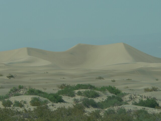 A quick side trip up to "Marble" Canyon a thousand feet higher than Pipestone Wells. It was too far for Denice to walk, but I did. Some great and neat canyon sights of a white polished marble. I'm surprised a quarry has not been started there. National Park I guess!!


 Then we headed home, up out of the canyon, a 13 mile climb. Sure glad we decided not to take ELTORO in, as it would have been quite a pull. Near Beatty stopped at Ryolite, an abandoned Ghost town, where gold was mined in the 1908 to1910 era.


Near 10,000 residents called Ryolite home during its heyday. Several of the old partial structures still stand, but in more recent times Ryolite has become a showcase of artistic sculptures at a museum close at hand. Several large ones are on display there in an outdoor setting.


 Arrived home at 8:00PM. Too late for supper, so had Chicken at "Wolfy's."
Day 2 - April 7th

Just a short day today. We wanted to see what the Ash Meadows Wildlife Refuge had to offer. This is a adjacent to the Death Valley National Park, and one small area, Devils Hole, is actually part of the Park. It is only about 20 miles out of Pahrump, so in the afternoon took a quick spin out there. Not a lot of new stuff. More desert, more cactus, more sand, you know the routine. But a couple of things we did find interesting, out in the desolate desert we came apon some big fresh water springs, real "Oasis's in the Desert."


These were life savers in the early years for prospectors and travelers through the country. We saw about 4 different clear clean springs. Each has its own rare and protected, near extinction pupfish.

These are very small (1 to 2" long) blue minnow type fish, and so the protected status of the Park and Refuge. This is the only place in the world where these are found, and populations hover around the couple of hundred at each site. The Devils Hole is just a very deep fissure into a mountain hillside, but tied into a subsurface watercourse.


The area is strictly protected with a chain link fence around it. Took a few pictures, but unable to really get close enough for good ones. Stopped at the Ranger Station and inquired about a road shown on the map as a unmaintained one to Crystal on Highway 95. Told it was good but Wash Boardy. The Lady Ranger says, "That if you have any trouble the ladies at the Crystal Brothel will be more than glad to help you out." Brothel ??? I had forgot they are still legal in Nevada. Now I have to go that way, and sure enough we ended up at "Madam Butterfly's."


Took some pictures, but the sign suggested going inside for a menu, bumper stickers, souvenirs, and etc,etc!!! Oh well!! Pictures will have to do.


Day 1 - April 6th

Today we went as far as Furnace Creek on CA190, with a short detour through 20 Mule Canyon Road, and then on to Harmony Borax Works, then returned south on he Badwater Road, stopping at The Devils Golf Coarse, Natural Bridges, Badwater, Mormons Point, and Ashford Mills. Then back through Shoshone on CA178 and back to Pahrump. The odometer in TOADONE registered 192 miles, an approximate 4 hour trip. We left at 9:00AM and back in Pahrump at 8:00PM. Eleven hours. Hmmmmm!!! Here is a glimpse of what took the whole day:
 Find Phiedieux?
On the 20 Mule Canyon Road

Zabriskie Point


In case you are wondering, That is Denice and I up there. Wink! Wink!

The Borax Wagon Trains


A friendly little Guy - He is over 1 foot long!

The Devils Golf Course


The Natural Bridge
 The Salt Flats at Badwater
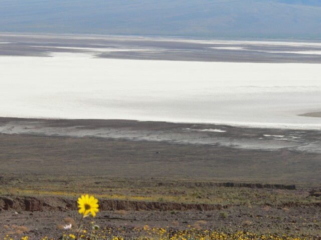


 Look close and you will be able to see where Sea Level Is. Top/Center
 The Desert is Abloom!!

No comments:
Post a Comment