Stayed in Coeur d'Alene for 3 days, just lazing around and waiting for weather to the north to clear so we could make the final run to the border. On the second day late in the afternoon a motorhome almost identical to ours pulled in and parked near us. It is a Newmar Kountry Star. The next morning we met our neighbors next door, the ones with the Kountry Star like ours. They are Paul and Bonnie Markland from Edson Alberta. They also have place in Valemont, BC, where they have a studio, as she is an Artist. Paul is a Construction guy building houses. They just bought the motorhome in Mesa and are importing it into Canada today at Porthill, going into Creston. Their motorhome is 37 ft and a 2005. They paid $60,000 for it. A Good Deal!! They invited us over to check it out. Almost identical to ours, except the extra 2 feet allows a back window with a small computer desk and a couple of easy chairs. Very nice !! Today Denice is working on our list of purchases while we have been down here, to present at the Canadian border when we cross tomorrow. We had planned on crossing today, but is showering, and we frown apon traveling in the rain. Clear in the early afternoon. Denice completes the cross border list, a total of $2875.86. Remove the $1500 we are allowed and we will have to pay 5% on $1375.86, approx $68.79. No big deal. If we had been on the ball when we returned to Canada via the Westjet Plane from Vegas we would have brought with us $1500 worth of souvineers, with no GST applicable. However we did not even have suitcases with us on that trip, so we declared nothing. Now on returning to the States the process starts over, and now we have to declare all that we bought. So on the 23rd we arrived at Kingsgate from Coeur d'Alene. Crossed USA/ Canada border with no major issues. Just regular questions about liquor, tobacco, and firearms, and how much we are bringing back. We advised the $2875.86, so he asked us to come in and declare, which we did. Paid an addditional $68.98 GST. Once that paid we were on our way. EASY EH!! Arrived Pincher Creek at a friends yard at about 4:00PM. No RV Campgrond open in Pincher Creek at this time of the year, but luckily we have lots of friends there so just set up shop in Keith and Carols yard. He has a big yard just across the creek from the Golf Course. I tried to convice him he should be building a RV Park there, as he has all the right equipmet to do the job, but he just doesn't seem interested. Funny, how when you get our age, building new things and committing yourself to long term work, managing a new facility, does not seem to have the draw that it once did. Anyway we set up down by his shop, and then we went and had a beer with them. They had a do to go to so we then went to Shannon's and then to dinner with them at Luigi's. Home to ELTORO by 8:00PM. Next day we had planned to head home, but we are waiting for our Granddaughter, Samantha, to bless us with another Great-Grandchild. She is due today, but no luck. We elected to even stay another day, but even that did not encourage any development. Monday, decided to head on home, and wait until the big event. Arrived High River before noon, and just got right after emptying out ELTORO. Wasn't that big of a job, as we were not worried about canned goods and other stuff in the pantry freezing. I am also not winterizing it, so keeping my fingers crossed, and watching the weather for frost warnings, counting on good weather from now on. 2009/2010 Winter Vacation now over
161 days total away, not accounting for the 4 days when we flew back home for the funeral.
Wednesday, April 28, 2010
Monday, April 19, 2010
Northward Bound
April 20th
Pulled out of Pasco by 8:00AM and headed north on 395. A pretty routine day.
Little to report as the route only encompassed 166 miles to Coeur d' Alene, where we were booked in at the Black Island RV Resort. The route was up highway 395 until it joined with I 90,and the east through Skokane and to Idaho at Stateline and then to Coeur d' Alene. Black Island RV Park is located right on the Spokane River where it starts at the outlet of Coeur d' Alene Lake. Seems like a very nice park. We are at site 55 in the outer circle of sites facing the pond out front. The layout of the site is in a big pin wheel with two circles, an inner and an outer, and all the RV's face out. These are the premium sites. There are many more ordinary sites, farther from the river, but we chose the more expensive site. With registration we were given two drink tickets at the Floating Cedars Restaurant on the Lake, if we had dinner there. We accepted and went over at 5:00PM. Food was great! Denice had her steak and Lobster dinner that I had promised her for her birthday last month. (She was unable to go out at that time due to that Gout attack of hers) I had prime rib, and it was excellent. We both suffered later in the evening for over eating!!
April 19th
Left Bend by about 9:00AM and headed north on highway 97. Route was much more scenic than I had remembered from prior trips. Several of the volcanic Mountains are easily visible from this route. Adams, Jefferson, Hood, St. Helens, to name a few. All were shrouded in a heavy coating of snow. I had remembered the route as being rather blah and desert type, but on this trip found that to only be the case for about 50 miles, before starting down into the Columbia Gorge. The majority is rather lush farmland, vineyards, vegetable crops, and hay land. Near the Columbia Gorge winds from the Pacific are common sweeping up the valley, so this becomes a likely place for wind turbines. Past trips, they were non existent, but this trip, WOW, there were hundreds, maybe even thousands lining both sides of the river, extending back for many miles on each side. Today was a poor power day though as only a very few were turning. Poor power day, but great traveling day!! Once in the Gorge we joined I 90 and headed east along the john Day Dam. The concrete dam itself is not all that high. I was about to say that it was probably less than 50 ft. high, but then I checked in Google and found a different story. I guess a drive by shooting is not always the best rule of thumb! Here are the actual dimensions:
Specifications
Altitude: 266 feet (81 m) above sea level
Height: 183 feet (56 m)
Length: 7,365 feet (2,327 m)
Navigation lock:
Single-lift
86 feet (26 m) wide
675 feet (206 m) long
Powerhouse
Sixteen 135,000 kW units
Total capacity: 2,160 MW
Overload capacity: 2,485 MW
Spillway
Gates: 20
Length: 1,228 feet (374 m)
We left I 90 at the upper end of Lake Umatilla (That is the name of the lake formed by the dam) and crossed the Columbia River just below the McNarry Dam. Very little of the Columbia River is free flowing anymore. One dam just ends and another begins all the way from Canada to the Pacific. After leaving the river it is only about 50 miles to the Tri-Cities, Kennewick, Pasco, and Richland. They are also on the Columbia, but it makes a lonng loop, whereas I 84 cuts across overland. We had reserved at a KOA Sandy Heights RV Resort in Pasco. Checked in for one more night
April 18th
Nice slow drive through GREAT forested lands today. In California they have speed limits that allow 65MPH for vehicles of 3 axles or less, 55MPH for over 3 axles, and 55MPH for any vehicle towing anything. That was us! It actually was quite nice just cruising along at 55!! We stayed on highway 89 from the park this morning until we got to I 5 at Shasta. Took some great shots of Mount Shasta buried in snow. Followed it a short distance (8 miles) and then turned off onto highway 97 and headed north on the other side of the mountain and on into Bend, Oregon. Just past Mount Shasta we pulled over at a point of interest. It was " The Living Memorial Sculpture Garden." Here sculpterer, Dennis Smith made metal sculptures of what his views of the wars that he was part of. Mor can be found on the web at
http://www.weedlmsg.org/01garden01intro.html


It was about a half mile walk to vie all of them but worth it. Then continued on north through Klamath Falls and up to Bend. We had reserved at the Crown Villa RV Resort. We had stayed here a couple of years ago in the premium area at $65/night, but this time chose the regular option at $42/night. It is pricey, but we believe it is the best park we have ever stayed at, bar none! Checked in for one night.

Friday, April 16, 2010
And then there was SNOW
April 16th
Drove down to Burney Falls. It is rather spectacular with a 129 foot fall into a deep green pool. A interesting thing about the falls, is it also comes out as large springs along a ledge of rock for about 100 ft either side of the main falls and approx 75 feet below the main crest. Being in volcanic rock, there must be fissures from above in the main stream to allow water to migrate deep into the rock layers and then follows a hard layer to where daylights to join the main falls. A nice viewpoint is at the top, and then a well built paved path to the pool at the bottom. Denice chose not to walk to the bottom, but I did. Well worth the time.


Then we drove back toward the RV park and went on past for another 20 miles to the entrance to Lassen Volcanic Park. We were pretty sure it would not be open at this time of the year as it is in "High Country" at about 6000 feet. Once we got there it was obvious why it wasn't open. About 4 feet of snow blocked the road at the closed gate sign, so we had to turn back.

Anyway it was still an interesting drive over Eskimo Pass, and the back to ELTORO. We had decided to have supper at the Rancheria Diner. It was very good. I just had veal cutlets and Denice had a Taco Salad.
April 15th
Today left Hawthorne and continued north on SR 95 up through Fallon and onto SR50 and I 80 into Reno. Desert environment starts to change as we move north. Less cactus, but still pretty bleak. Then as we approach Sparks and Reno we drop into a deep valley with high hills and mountains on each side No urge to leave any money at the casinos here, so just kept on going north on SR 395 toward Susanville.

 Got into the middle of a political protest in Susanville. Obvious from the placards that everyone in the USA is not an Obama fan. We think he is doing a good job, but we did hear lots of negative remarks while in the south. I guess old feelings die hard!!
Prior to Susanville at the Califonnia State Line, we of course, had to pass through their inspection. The inspector requested entry into ELTORO. He checked the fridge and the shower, not sure what he expected to find there, but on the table we had a bowl of fruit. So now California inspection now has a couple of Florida oranges!! They were slightly dried up and full of seeds anyway. He asked if we had any wood, so I told him just some blocking for the motorhome. Well I guess it could be used for blocking, or maybe lathe turning!! Once inside California topo changes dramatically. Start to see green valleys and lakes that actually have water in them. Elevation continues to climb up to the 5 to 6000 ft levels. Snow levels on the mountains grow closer to the highway, and yes, even right to the edge sometimes with a couple of feet in the ditches, BUT NONE ON THE ROAD. We were in the Lassen National Forest and were surrounded by huge pine and cedar trees, a welcome relief from the desert snd cactus over the last month or two.

We wanted to go this way to see the Lassen Volcano sites near the junction with SR44, so wanted to stay a day or two to check them out, needed a RV park close by. I had called to Lassen Volcanic Park headquaters yesterday about their camping sites and was told by Mike that theirs had no hookups, but if I just went north on SR44 that there was a nice park called Rancheria RV Resort. So at this junction we went the five miles north and pulled into the Resort at Hat Creek. I had googled it and then called them for a reservation. It is a beautiful little Park under large pine and cedar trees. Checked in and was given a pull through. It was out in the sun, but after setting up and then walking around found a much nicer site right on their little lake. Requested a move and was approved. Moved over and settled in for 2 nights

April 14th
And according to the plan developed last night we headed north.
Today drove a lot of blah, blah,blah desert with little to see. I guess the highlights would be a couple of passes that we navigated over. The first was at 5200 ft, I think and the second was at Tonopah at 6200ft.


Tonopah itself is over 6000 ft, quite a neat little town. Lots of mining history here for gold, silver, and lead. Then on to Hawthorne where we pulled up for the night at the Whiskey Flats RV Park. Coming into Hawthorne we noticed hundreds of bunker type structures and were unsure what they represented, so when registering at the RV park I inquired and was told this was the largest ammunition storage site in the Continental USA, although not active anymore.


More can be found on the Web. Here is an excerpt:
Hawthorne was established in Mineral County in 1881 on the western side of Nevada. It sits at an elevation of 4,255 feet and is surrounded by several mountain ranges that protect it from extreme weather allowing for nearly 365 days of sunshine a year and relatively mild temperatures.
Walker Lake, fed from the north by the Walker River, is the heart of outdoor recreation in Hawthorne. This lake was once part of the Lahontan Sea, a prehistoric sea that covered much of Nevada and is now home to several species of water birds, including loons, and the Lahontan cutthroat trout.
Hawthorne is called “America’s Patriotic Home,” and the red, white and blue streets and flags blowing in the wind are testament to the town’s great national pride. Part of this pride is rooted in the Hawthorne Army Depot, an ammunition storage site south of Walker Lake. Construction began on the facility in 1928 and it served as an ammunition staging area for World War II. It is said to be the largest facility of its kind in the world, covering more than 147,000 acres. Today, the depot employs a large majority of the residents of Hawthorne.
The Hawthorne Ordnance Museum is a great place to see some of this ammunition up close, and see a variety of military uniforms, photos and memorabilia.
There are several hotels and motels in Hawthorne, and restaurants to suit any craving. The El Capitan Lodge and Casino is the largest stopover, complete with 24-hour Nevada-style gaming, a cocktail bar and lounge, a coffee shop, and RV and truck parking. It is also close to the Walker Lake Golf Course.
April 13th
Rest Day in Pahrump
Moving Day preparations for tomorrow
Pick up a few groceries - just some staples as we need to eat some of the food we already have in the frig and freezer
Decision Day - what route to home. A couple of options, back to Vegas and up I 15 as we have always done, or north on 95 and up to Ely and Wendover, then to Salt Lake City and home on I 15, or new to us, up 95 and then over to Reno, north to I 5 for a short distance, then through Klamath Falls, OR, and into the Columbia basin and work home from there through customs at Yahk, BC. Shouldn't be too much snow at this time of year, but we will be going through some high country. Lets take a shot at it. Decision done!! Get onto "Streets and Trips" and lay it out.
Tuesday, April 13, 2010
Yea, Though I Walk Through the Valley of Death
I have now walked there and it would seem appropriate to have a Rod and Staff or something to comfort one there. It is a desolate unforgiving valley. From the National Park Website:

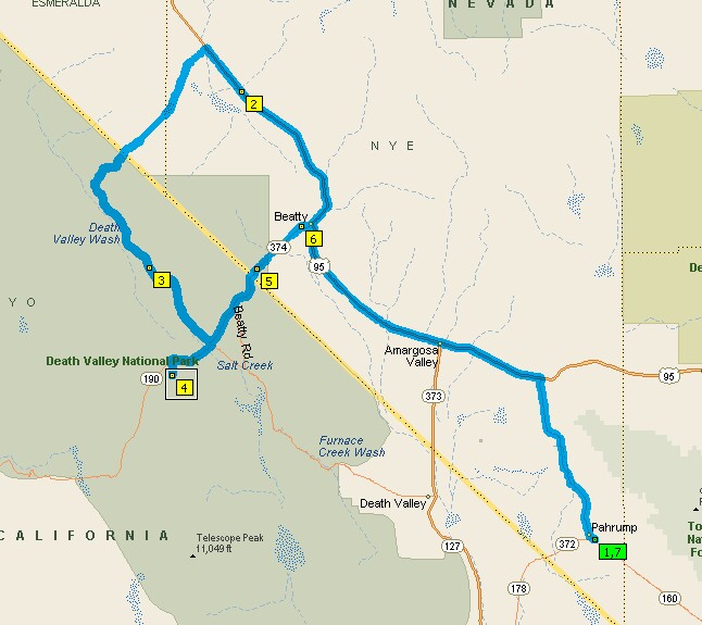
Today we went as far as Furnace Creek on CA190, with a short detour through 20 Mule Canyon Road, and then on to Harmony Borax Works, then returned south on he Badwater Road, stopping at The Devils Golf Coarse, Natural Bridges, Badwater, Mormons Point, and Ashford Mills. Then back through Shoshone on CA178 and back to Pahrump. The odometer in TOADONE registered 192 miles, an approximate 4 hour trip. We left at 9:00AM and back in Pahrump at 8:00PM. Eleven hours. Hmmmmm!!! Here is a glimpse of what took the whole day:
 Find Phiedieux?
On the 20 Mule Canyon Road


In case you are wondering, That is Denice and I up there. Wink! Wink!


 The Salt Flats at Badwater


 Look close and you will be able to see where Sea Level Is. Top/Center
 The Desert is Abloom!!


Death Valley National Park: A Land of Extremes
Hottest, Driest, Lowest: A superlative desert of streaming sand dunes, snow-capped mountains, multicolored rock layers, water-fluted canyons and 3 million acres of wilderness. Home to the Timbisha Shoshone people and to plants and animals unique to the harshest desert.
After arriving, and finding it such a large expanse, we had tentatively decided to divide he total package into about 3 days.Oops! Day 4 - April 12th
 Original Plan, 3 days, but as we have said before, our plans are cast in Jello, and are changing continually. We have had 3 good days in the Valley, but there still is a couple more things we would like to see. Now seeing this may be the only chance in this life time to see them we decided we better go. They were namely Titus Canyon Road and Dante's overview.Down to Death Valley for the 4th time. Go to Beatty and then south a few miles until start of Titus Canyon one way Road and follow it for 26 miles to Scotty's Castle Road. The first 10 miles is a wash boardy dirt road and rather flat desert type topo, gradually climbing until you come to an abrupt canyon. At this point the elevation is near 5000 ft. Proceeding onward, the road narrows and drops sharply into a deep valley and immediately climbs a long steep side slope up to 5500 ft at Red Pass, and then down at about a 20% grade toward Titus Canyon proper. Denice, being terrified of narrow roads and heights, did remarkably well. At some points she was leaning way over to my side to help stabilize Toadone, and sometimes she was just very quite, but on the whole did very well.


Once down into the canyon she relaxed a whole bunch. Although the road was very rough with big boulders protruding out of the surface, at least it was on flatter terrain. The Park Guide had colled this a 4 wheeled high clearance vehicle road. They had called it correctly, although we did see one car that had managed to negotiate it. Must have been a rental!! First item of interest was to old Ghost Town of Leadfield. A partial note from:
http://mojavedesert.net/mining-history/leadfield/
The ghost town of Leadfield has become identified in western mining lore as an example of fraud, deception and deceit at its worst. Located in the middle of Titus Canyon about twenty-two miles west of. Beatty, Leadfield boomed briefly in 1925 and 1926. The extensive promotion which surrounded the camp, the unsavory character of its chief promoter, and the swift and sudden demise of the boom has led to unkind treatment at the hands of popular writers of western history. Betty J. Tucker, writing in a 1971 issue of Desert Magazine is a good example: This town was the brain child of C. C. Julian, who could have sold ice to an Eskimo. He wandered into Titus Canyon with money on his mind. He blasted some tunnels and liberally salted them with lead ore he had brought from Tonopah. Then he sat down and drew up some enticing, maps of the area. He moved the usually dry and never deep Amargosa River miles from its normal bed. He drew pictures of ships steaming up the river hauling out the bountiful ore from his mines. Then he distributed handbills and lured Eastern promoters into investing money. Miners flocked in at the scent of a big strike and dug their hopeful holes. They built a few shacks. Julian was such a promoter he even conned the U. S. Government into building a post office here. So goes, the usual, tale, which is fairly well duplicated by most writers of popular lore over the past forty-odd years. The true story, however, is somewhat different. Although Leadfield did set a record of sorts for being one of the shortest-lived towns in western mining history, there was more to it than merely an out-and-out stock swindle. Nor can C. C. Julian be blamed solely for the life and death of Leadfield.
Go to the web site for the rest of the story.


After Leadfield we now went right into the deeply incised Titus Canyon Valley. We continue to follow a dry river bed into a deepening and narrowing canyon. Majestic vistas, unique plant life, and claustraphobic verticle canyon walls towering hundreds of feet above, offer the hardy traveler a memorable experience. We had a picnic lunch in one of the really tight narrow spots. Sure hope it doesn't rain up the canyon. A flash flood would be a horror story, as the canyon at this point this only just wide enough for one vehicle, hence the requirement for only one way traffic.


After exiting the canyon we traveled south past Furnace Creek, and took a 13 mile side trip the Dante's View Point. Again the elevation climbs from about 2300 ft at the start to 5475 ft at the Viewpoint, in only 13 miles. The last 1/4 mile has a 15% grade. As you approach the top and come around the last corner, you are overwhelmed by the vista before you. If you read my Day 1 posting you will see pictures I took from Bad Water at 282 feet below sea level. Now here we are right above that very same spot but 5475 feet above sea level. Look closely at his picture and you can in fact see people walking out onto the salt flats. Also enjoywith me the panorama photo from the top.

 Today was windy and cool up here so we just snapped a few good shots and headed on down and toward home. Along the 13 mile section a lot of old borax mining activity is still visible, and I found that interesting as well.

Home by 7:00PM.
Day 3 - April 9th
 Out to Death Valley - Long Day - 294 miles
Left ELTORO by about 8:30AM and traveled on SR160 to junction with 93, then through Beatty, and on the Scotty Castle Junction, a distance of about 120 miles. Then we went down to Scotty's Castle, and had a picnic lunch Denice had prepared. Toured around the castle grounds, although did not take any of the tours.


 From there we wanted to go to Ubeheba Crater, but were unable to, due to ongoing construction there, so we just worked our way to the south, through the Valley. Lots of stops to view flowers and stuff. Went into the Sand Dunes at Pipestone Wells.
 A quick side trip up to "Marble" Canyon a thousand feet higher than Pipestone Wells. It was too far for Denice to walk, but I did. Some great and neat canyon sights of a white polished marble. I'm surprised a quarry has not been started there. National Park I guess!!


 Then we headed home, up out of the canyon, a 13 mile climb. Sure glad we decided not to take ELTORO in, as it would have been quite a pull. Near Beatty stopped at Ryolite, an abandoned Ghost town, where gold was mined in the 1908 to1910 era.


Near 10,000 residents called Ryolite home during its heyday. Several of the old partial structures still stand, but in more recent times Ryolite has become a showcase of artistic sculptures at a museum close at hand. Several large ones are on display there in an outdoor setting.


 Arrived home at 8:00PM. Too late for supper, so had Chicken at "Wolfy's."
Day 2 - April 7th

Just a short day today. We wanted to see what the Ash Meadows Wildlife Refuge had to offer. This is a adjacent to the Death Valley National Park, and one small area, Devils Hole, is actually part of the Park. It is only about 20 miles out of Pahrump, so in the afternoon took a quick spin out there. Not a lot of new stuff. More desert, more cactus, more sand, you know the routine. But a couple of things we did find interesting, out in the desolate desert we came apon some big fresh water springs, real "Oasis's in the Desert."


These were life savers in the early years for prospectors and travelers through the country. We saw about 4 different clear clean springs. Each has its own rare and protected, near extinction pupfish.

These are very small (1 to 2" long) blue minnow type fish, and so the protected status of the Park and Refuge. This is the only place in the world where these are found, and populations hover around the couple of hundred at each site. The Devils Hole is just a very deep fissure into a mountain hillside, but tied into a subsurface watercourse.


The area is strictly protected with a chain link fence around it. Took a few pictures, but unable to really get close enough for good ones. Stopped at the Ranger Station and inquired about a road shown on the map as a unmaintained one to Crystal on Highway 95. Told it was good but Wash Boardy. The Lady Ranger says, "That if you have any trouble the ladies at the Crystal Brothel will be more than glad to help you out." Brothel ??? I had forgot they are still legal in Nevada. Now I have to go that way, and sure enough we ended up at "Madam Butterfly's."


Took some pictures, but the sign suggested going inside for a menu, bumper stickers, souvenirs, and etc,etc!!! Oh well!! Pictures will have to do.


Day 1 - April 6th
 Original Plan, 3 days, but as we have said before, our plans are cast in Jello, and are changing continually. We have had 3 good days in the Valley, but there still is a couple more things we would like to see. Now seeing this may be the only chance in this life time to see them we decided we better go. They were namely Titus Canyon Road and Dante's overview.Down to Death Valley for the 4th time. Go to Beatty and then south a few miles until start of Titus Canyon one way Road and follow it for 26 miles to Scotty's Castle Road. The first 10 miles is a wash boardy dirt road and rather flat desert type topo, gradually climbing until you come to an abrupt canyon. At this point the elevation is near 5000 ft. Proceeding onward, the road narrows and drops sharply into a deep valley and immediately climbs a long steep side slope up to 5500 ft at Red Pass, and then down at about a 20% grade toward Titus Canyon proper. Denice, being terrified of narrow roads and heights, did remarkably well. At some points she was leaning way over to my side to help stabilize Toadone, and sometimes she was just very quite, but on the whole did very well.


Once down into the canyon she relaxed a whole bunch. Although the road was very rough with big boulders protruding out of the surface, at least it was on flatter terrain. The Park Guide had colled this a 4 wheeled high clearance vehicle road. They had called it correctly, although we did see one car that had managed to negotiate it. Must have been a rental!! First item of interest was to old Ghost Town of Leadfield. A partial note from:
http://mojavedesert.net/mining-history/leadfield/
The ghost town of Leadfield has become identified in western mining lore as an example of fraud, deception and deceit at its worst. Located in the middle of Titus Canyon about twenty-two miles west of. Beatty, Leadfield boomed briefly in 1925 and 1926. The extensive promotion which surrounded the camp, the unsavory character of its chief promoter, and the swift and sudden demise of the boom has led to unkind treatment at the hands of popular writers of western history. Betty J. Tucker, writing in a 1971 issue of Desert Magazine is a good example: This town was the brain child of C. C. Julian, who could have sold ice to an Eskimo. He wandered into Titus Canyon with money on his mind. He blasted some tunnels and liberally salted them with lead ore he had brought from Tonopah. Then he sat down and drew up some enticing, maps of the area. He moved the usually dry and never deep Amargosa River miles from its normal bed. He drew pictures of ships steaming up the river hauling out the bountiful ore from his mines. Then he distributed handbills and lured Eastern promoters into investing money. Miners flocked in at the scent of a big strike and dug their hopeful holes. They built a few shacks. Julian was such a promoter he even conned the U. S. Government into building a post office here. So goes, the usual, tale, which is fairly well duplicated by most writers of popular lore over the past forty-odd years. The true story, however, is somewhat different. Although Leadfield did set a record of sorts for being one of the shortest-lived towns in western mining history, there was more to it than merely an out-and-out stock swindle. Nor can C. C. Julian be blamed solely for the life and death of Leadfield.
Go to the web site for the rest of the story.


After Leadfield we now went right into the deeply incised Titus Canyon Valley. We continue to follow a dry river bed into a deepening and narrowing canyon. Majestic vistas, unique plant life, and claustraphobic verticle canyon walls towering hundreds of feet above, offer the hardy traveler a memorable experience. We had a picnic lunch in one of the really tight narrow spots. Sure hope it doesn't rain up the canyon. A flash flood would be a horror story, as the canyon at this point this only just wide enough for one vehicle, hence the requirement for only one way traffic.


After exiting the canyon we traveled south past Furnace Creek, and took a 13 mile side trip the Dante's View Point. Again the elevation climbs from about 2300 ft at the start to 5475 ft at the Viewpoint, in only 13 miles. The last 1/4 mile has a 15% grade. As you approach the top and come around the last corner, you are overwhelmed by the vista before you. If you read my Day 1 posting you will see pictures I took from Bad Water at 282 feet below sea level. Now here we are right above that very same spot but 5475 feet above sea level. Look closely at his picture and you can in fact see people walking out onto the salt flats. Also enjoywith me the panorama photo from the top.

 Today was windy and cool up here so we just snapped a few good shots and headed on down and toward home. Along the 13 mile section a lot of old borax mining activity is still visible, and I found that interesting as well.
Home by 7:00PM.
Day 3 - April 9th
 Out to Death Valley - Long Day - 294 miles

 From there we wanted to go to Ubeheba Crater, but were unable to, due to ongoing construction there, so we just worked our way to the south, through the Valley. Lots of stops to view flowers and stuff. Went into the Sand Dunes at Pipestone Wells.
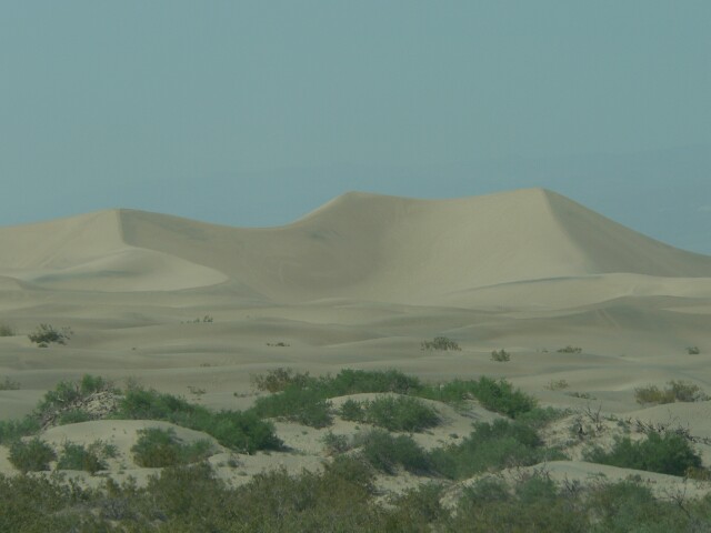 A quick side trip up to "Marble" Canyon a thousand feet higher than Pipestone Wells. It was too far for Denice to walk, but I did. Some great and neat canyon sights of a white polished marble. I'm surprised a quarry has not been started there. National Park I guess!!


 Then we headed home, up out of the canyon, a 13 mile climb. Sure glad we decided not to take ELTORO in, as it would have been quite a pull. Near Beatty stopped at Ryolite, an abandoned Ghost town, where gold was mined in the 1908 to1910 era.


Near 10,000 residents called Ryolite home during its heyday. Several of the old partial structures still stand, but in more recent times Ryolite has become a showcase of artistic sculptures at a museum close at hand. Several large ones are on display there in an outdoor setting.


 Arrived home at 8:00PM. Too late for supper, so had Chicken at "Wolfy's."
Day 2 - April 7th

Just a short day today. We wanted to see what the Ash Meadows Wildlife Refuge had to offer. This is a adjacent to the Death Valley National Park, and one small area, Devils Hole, is actually part of the Park. It is only about 20 miles out of Pahrump, so in the afternoon took a quick spin out there. Not a lot of new stuff. More desert, more cactus, more sand, you know the routine. But a couple of things we did find interesting, out in the desolate desert we came apon some big fresh water springs, real "Oasis's in the Desert."


These were life savers in the early years for prospectors and travelers through the country. We saw about 4 different clear clean springs. Each has its own rare and protected, near extinction pupfish.

These are very small (1 to 2" long) blue minnow type fish, and so the protected status of the Park and Refuge. This is the only place in the world where these are found, and populations hover around the couple of hundred at each site. The Devils Hole is just a very deep fissure into a mountain hillside, but tied into a subsurface watercourse.


The area is strictly protected with a chain link fence around it. Took a few pictures, but unable to really get close enough for good ones. Stopped at the Ranger Station and inquired about a road shown on the map as a unmaintained one to Crystal on Highway 95. Told it was good but Wash Boardy. The Lady Ranger says, "That if you have any trouble the ladies at the Crystal Brothel will be more than glad to help you out." Brothel ??? I had forgot they are still legal in Nevada. Now I have to go that way, and sure enough we ended up at "Madam Butterfly's."


Took some pictures, but the sign suggested going inside for a menu, bumper stickers, souvenirs, and etc,etc!!! Oh well!! Pictures will have to do.


Day 1 - April 6th

Today we went as far as Furnace Creek on CA190, with a short detour through 20 Mule Canyon Road, and then on to Harmony Borax Works, then returned south on he Badwater Road, stopping at The Devils Golf Coarse, Natural Bridges, Badwater, Mormons Point, and Ashford Mills. Then back through Shoshone on CA178 and back to Pahrump. The odometer in TOADONE registered 192 miles, an approximate 4 hour trip. We left at 9:00AM and back in Pahrump at 8:00PM. Eleven hours. Hmmmmm!!! Here is a glimpse of what took the whole day:
 Find Phiedieux?
On the 20 Mule Canyon Road

Zabriskie Point


In case you are wondering, That is Denice and I up there. Wink! Wink!

The Borax Wagon Trains


A friendly little Guy - He is over 1 foot long!

The Devils Golf Course


The Natural Bridge
 The Salt Flats at Badwater
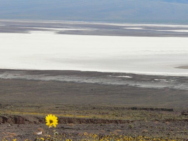


 Look close and you will be able to see where Sea Level Is. Top/Center
 The Desert is Abloom!!

Subscribe to:
Comments (Atom)