This morning is "Pea Soup" fog again, so we waited at the hotel until about 10:00AM before heading out. We wanted to go east along the south coast as far as the road goes. That is about 40 miles and ends at an old restored lighthouse and town called Rose Blanche.It was foggy most of the way down, but a few times the sun tried to peak through. It was still fog at the light house, but we did a leisure walk up to it with a guide who detailed all the history associated with it.
 We took some photos, but were not the best, given the conditions. On the way back we just took our time, slow and easy. The fog was lifting, and along that southern coast there are lots of small fishing villages. These are more like the ones that we had envisioned for Newfoundland.


 These are the REAL Newfoundland - at least what we had envisioned!!
 We returned along the street until we found one of the portable Chip Stands where we bought burgers. Took them to our hotel and enjoyed dinner.
Sept 30th
This morning is "Pea Soup" fog. Had to scrap our planned tour to Cape St. George as we would not be able to see any thing any way. Headed back to TC#1 and toward Port aux Basques. By noon the fog did start to lift. As we got closer to Port aux Basques conditions continued to improve enough that we took a side road out to a couple of other coves. At the end of the road at Cape Anguille, another lighthouse . Most of these are still active, and on foggy days like today the fog horns are blaring every few minutes. This area is a bit of surprise as there is some nice farm land and very pastoral scenery.


 The colors are changing
 A Residence sign - Well Done
Then closer to Port aux Basques we went out to another, Cape Ray. Another light house and some big waves breaking on the rocky shore line.


 In to Port aux Basque by about 4:30PM and check into the hotel. For dinner we tried some local cuisine. Denice had cod and scrunchions. I, a cod tongue dinner. They were OK, but wouldn't recommend a steady diet of them. Still need to try the cod cheeks and brewis.
 Toward sunset I took a walk down along the bay and onto the Trans Canada Hiking Trail. It starts its Newfoundland section here in Port aux Basques and uses to old abondoned Newfie Bullet Train rail bed all the way to St Johns, a distance of over 800 kilometers. I hiked a couple, and took some great sunset shots.

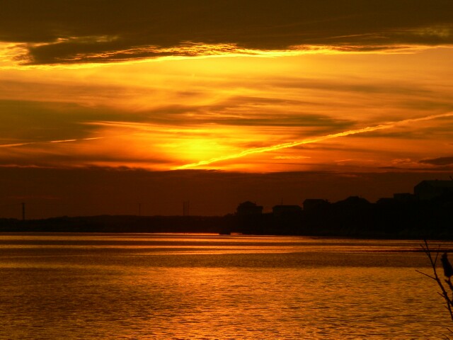 A Nice Sunset


 The Newfie Bullet
Woke up this morning to heavy rain. Must have rained all night as it was doing the same thing when we retired last night. Headed south toward Gros Morne National Park. The weather was intermittent showers all day with at times heavy rain most of the time and at other times Heavy Rain and at still other times heavy, heavy rain. There was no letup all day.
 This was not a picture taking day, although we did get a couple of an old cow moose beside a slough, just enjoying the wet weather. We made no stops in the park, as there was no point. Next stop was at an info place in Deer Lake where we decided to take a side trip out to Stephenville. We had them reserve a room for us at the Stephenville Hotel. Lunch was at Tim Horton's at Marble Mountain just outside Corner Brook, then on south again. Turned west to Stephenville. The weather was real ugly. High winds and very heavy rain. Reached Stephenville after 20 miles and found the Hotel and checked in by 2:00PM. This is as far as we are going today!! Just crashed in the room and had a short nap. 7:00pM had a Chinese Cafe deliver some Chinese Food to us. All for today. Hope tomorrow is better!! No update on log tonight as WIFI is down due to wet weather.
Sept 28th
Left St. Anthony's this morning and headed back south along The Viking Trail Route 430. At St. Anthony's Airport turn off, turned east onto Route 432. This is a circle route that joins the Viking Trail some 100 miles south. On this section I wanted to see an underground Salmon Pool at a place called, Roddickton. We did find it, but after driving a few kilometers on a gravel road, and then walking in 1/2 kilometer found it was just a pool that flowed out from a limestone cave. Apparently the salmon come up river to this point, but can go no further. Today there was none that I could see, but the water here is almost black from coming out of muskeg type conditions.

 This was a bit of a wasted effort, but still a nice walk. Denice opted to stay at the jeep, and I guess she was the smart one. After that the weather started to deteriorate and light rain started to fall. If the sun had been shining, the fall colors would have been better, but hopefully we will see lots of that when we head south into the States unless as reported, it as been too dry for them to get to the brilliant colors that are normal. We traveled south until we came to Hawkens Bay at about 1:30PM. We checked into the same Inn that we were in on the way up. Then we went out to a couple of little coves, namely Port au Choix and Port Saunders. At Port au Choix there is a National Historic site and light house.


The National Historic site detailed the habitation of the area going back up to 4000 years. Then the Light House that is still active is out on a rocky point, but the weather was rather wild today with strong winds, rain, and cool temperatures, so the visit was brief.

Then a quick tour of Port Saunders. Seems by the amount of large fishing boats in Dry Dock that this is a major fishing village, but we didn't stay around long enough to research further. No update on log tonight as WIFI is down due to wet weather.

Sept 27th


Headed north again by 8:00AM this morning along the rocky coast line of Newfoundland. We are surprised by the number of small coastal communities along the coast. Seems every couple of miles there is another Cove or Brook. There are away too many names to even try to repeat. The day was windy so the incoming waves were quite large breaking on the very rocky shore. It is no wonder there were so many ships wrecked along this coast. Many of them likely sought refuge from storms, into these somewhat protected coves, but once they entered, I'm sure they would have found them a way too shallow to navigate and were likely driven onto the rocks. There are several things that have surprised us. We had this picture of steep rocky coves with a windy little road down to it, with little room to even turn around. This is not the case, at least on this northern coast. Maybe it is for the southern coast. But here the coast line is actually quite flat. Lands away from the coast are tundra type flatland with ponds everywhere, and few trees. Neat fishermen's houses dot the shorelines and Lobster traps are stored by the thousands along the beach in every opening and flat place available. I'm not sure how they know whose is whose, or maybe it doesn't matter. Just use what you need?? Another surprise.
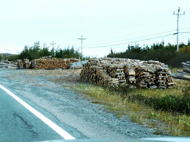
 Firewood is piled along the road, even more often than Lobster traps. Now I am sure everyone does burn firewood for heat and cooking here, but I'm thinking there must be some kind of a "Government Make Work Program" here to help winter employment. The wood piles are everywhere and are large and neatly piled with no indication of any issues with just loading up what you need, and taking it on home. One other interesting item. The whole shoreline, as I stated before is solid rock, so nothing can be grown there near the houses, but it seems everyone wants a garden to grow some veggies. So where is the most topsoil? Well it would seem likely when the built the highway, the surface soil was scraped off and spread out along the ditches for revegetation. So where are the gardens? All along the ditches!!1 Most protected by a pole fence around their plot. Some are right up onto the shoulder of the highway. Anyway we worked our way north, and at one point pulled into St Barbe, where the Labrador ferry docks, and were just in time to watch it come in and unload. There were a few motorhomes and fifth wheels that disembarked from it and one motorhome was waiting too load. I suppose they had come all the way from the North shore of the St Lawrence at Baie Comeau, up through Labrador to Churchill Falls and then across to NewfeeLand. Would be quite a trip. We had thought of that but discounted it because of distance and unknowns. We continued on right to the most northerly point accessable where the Vikings sailed to about 1000 years ago. This is L-anse aux Meadows National Park


There is not a lot to see here, buy what there is is well done. Several structures have been built exactly as the vikings had built theirs. Archeolical digs have taken place to gather info and the original footings are still viseable today. It was acold windy day, and it is quite a walk from the park info site to the actual building site, so we welcomed an invitation from on site staff costumed in the togs of the day to enter into the large communinal house made of peat bog sod walls and dirt over a stick supported "A-Frame Roof" structure. Dense live grass covered the entire structure. The staff there answered all our questions and told us that the Vikings most likely lived there for about 10 years before abandoning it, and returning home to Norway. After leaving there we were ready for some lunch so stopped at Gunner's Cove at the Northern Delight Restaurant for some lunch. I selected "A Newfoundland Brewis" Didn't know what it was other that it was Cod and hard Tack with Scrunchions. Found out later that scrunchions are salt pork and onions, however the restaurant was out, and were not getting more in as it is too late in the sason, so had to change to fish and chips. After lunch worked our way back to St Anthony's and to the motel we had reserved.
Sept 26th
After having breakfast at the hotel we headed north and east on the TCH#1 Highway along the western shore of Newfoundland, as far as Deer Lake and the turned onto #430 on the Viking Trail.

We had decided to journey as far north as we could go, to the point where the Viking's first came to the Western World at L'Anse aux Meadows near St Anthony, as soon as we could reach that point.The weather forecast is good for the next couple of days, so we will try to see all that we can before it deteriorates later in the week, then we will work our way back at a more leisurely pace, and try to take in those spots that we missed coming up. For lunch we stopped at a Tim Horton's for a coffee and a sandwich "to go" as well as some doughnuts, to save time.
 The Colors are starting to Change


 A Light House
 Ship Wrecked Parts of the Bessie Wreck of 1919


Through the Arch at Arches Prov. Park
 A Natural Paved Beach at Hawkes Bay
This was a good one and would have been a fantastic shot (with a camera, of course) if I had been able to get stopped a little sooner, and not tried to back up to get a better position, but we did get a couple of fair ones anyway, if only to prove we actually saw one. Arrived in Hawkes Bay by about 5:30PM .
Sept 25th
Up this morning and get in lineup for Sydney to Port aux Basque ferry by 9:45AM for a 11:30AM departure. Finally at about 11:00AM we were allowed to load.

We were directed to level #2 that is right in the bottom of the large Atlantic Vision ferry. We went into the lower deck #3, then made a loop completely around the inside of Deck #3 before going down a rather steep ramp into the deep hold of the ship. This deck only held about 25 cars. The we took the elevator to observation deck #7 where we found a table right at the front viewing area, with a great view of any thing approaching. For the next 5 hours we basicly saw nothing but waves and ocean.


Then at 6:00PM Newfoundland time ( after we advanced our watches by 1/2 hour) we arrived in Port aux Basque. This port is very small for such large ferries with rock outcroppings on all sides.

Just to complicates matters more, the ferry turns around right in the mouth of the port, and backs into the dock to allow disembarking. While rotating there couldn't have been much more that 100 feet clearance from the bow and stern to the rocks. We, being in the bottom deck were the last to get out. We had reserved at the Port aux Basque Hotel for the night and found it easily as Port aux Basque is not a very large town. Had dinner there after checking in.
Was Denice up coaching the skipper when he made that tight spin.
ReplyDelete